
Republic of Cabo Verde
República de Cabo Verde
República de Cabo Verde
Government type Semi-presidential republic
Area 4,033 km² (1,557 sq mi)
Population 491,000 inh. (2021 census)
Population 517,000 inh. (2026 est.)
Population density 128 inh/km² (332 inh/mi²)
Area 4,033 km² (1,557 sq mi)
Population 491,000 inh. (2021 census)
Population 517,000 inh. (2026 est.)
Population density 128 inh/km² (332 inh/mi²)
Capital Praia (159,000 pop.)
Currency Cape Verdean escudo
Human development index 0.668 (135th place)
Languages Portuguese (official), Creole
Life expectancy M 69 years, F 76 years
Currency Cape Verdean escudo
Human development index 0.668 (135th place)
Languages Portuguese (official), Creole
Life expectancy M 69 years, F 76 years
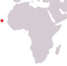
Boundaries:
Surrounded by the Atlantic Ocean
GEOGRAPHY DATA OF CAPE VERDE
Largest cities
Praia 159,000 pop.
Mindelo 71,000 pop.
Highest mountains
Pico do Fogo 2,829 m (9,281 ft)
Largest islands
Santiago 991 km² (383 sq mi)
Santo Antão 779 km² (301 sq mi)
Boa Vista 620 km² (239 sq mi)
Fogo 476 km² (184 sq mi)
São Nicolau 343 km² (132 sq mi)