
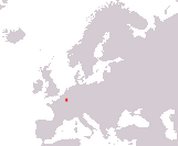
Grand Duchy of Luxembourg
Groussherzogtum Lëtzebuerg
Grand-Duché de Luxembourg
Großherzogtum Luxemburg
Groussherzogtum Lëtzebuerg
Grand-Duché de Luxembourg
Großherzogtum Luxemburg
Government type Parliamentary constitutional monarchy
Area 2,586 km² (998 sq mi)
Population 512,000 inh. (2011 census)
Population 690,000 inh. (2026 est.)
Population density 267 inh/km² (691 inh/mi²)
Area 2,586 km² (998 sq mi)
Population 512,000 inh. (2011 census)
Population 690,000 inh. (2026 est.)
Population density 267 inh/km² (691 inh/mi²)
Capital Luxembourg (136,000 pop.)
Currency Euro
Human development index 0.922 (25th place)
Languages Luxembourgish, French, German (all official)
Life expectancy M 81 years, F 85 years
Currency Euro
Human development index 0.922 (25th place)
Languages Luxembourgish, French, German (all official)
Life expectancy M 81 years, F 85 years
GEOGRAPHY DATA OF LUXEMBOURG
Largest cities
Luxembourg 136,000 pop.
Esch-sur-Alzette 37,900 pop.
Differdange 30,800 pop.
Dudelange 22,200 pop.
Pétange 21,100 pop.
Highest mountains
Kneiff 560 m (1,837 ft)
Longest rivers
Moselle 545 km (339 mi) total, 37 km (23 mi) in Luxembourg
Sûre 173 km (107 mi) total, 160 km (99 mi) in Luxembourg
Largest lakes
Lac de la Haute-Sûre (artificial) 3.8 km² (1.5 sq mi)
ADMINISTRATIVE DIVISIONS OF LUXEMBOURG
Luxembourg is administratively divided into 12 cantons; that of Clervaux in the northern extremity of the country is the largest, while the two southern cantons of the capital Luxembourg and Esch-sur-Alzette are by far the most populated and house together 60% of the total population.All the inhabited centers over 10,000 inhabitants are located in the southern part of Luxembourg, while in the rest of the country there are only smaller villages, as can be seen from the second map.