
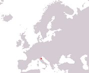
Republic of San Marino
Serenissima Repubblica di San Marino
Serenissima Repubblica di San Marino
Government type Parliamentary republic
Area 61 km² (23.6 sq mi)
Population 34,200 inh. (2026)
Population density 561 inh/km² (1,449 inh/mi²)
Area 61 km² (23.6 sq mi)
Population 34,200 inh. (2026)
Population density 561 inh/km² (1,449 inh/mi²)
Capital San Marino (4,200 pop.)
Currency Euro
Human development index 0.915 (29th place)
Languages Italian
Life expectancy M 83 years, F 87 years
Currency Euro
Human development index 0.915 (29th place)
Languages Italian
Life expectancy M 83 years, F 87 years
GEOGRAPHY DATA OF SAN MARINO
Largest cities
Serravalle 11,300 pop.
Borgo Maggiore 7,000 pop.
San Marino 4,200 pop.
Highest mountains
Monte Titano 755 m (2,477 ft)
Longest rivers
Ausa 17.2 km (10.7 mi) total, including the Italian stretch