Home > North America > United States > Longest rivers
 In the United States of America flow several of the major rivers of North America, thanks to the territorial extension of the country, slightly less than in neighboring Canada, with which it shares some waterways, starting from Yukon and St. Lawrence, both long over 3,000 kilometers.
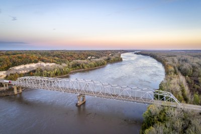
The longest river in the US is the Missouri, which is the main tributary of the Mississippi, which however has a shorter course of almost 500 kilometers, considering for the first its most remote source, which gives life to Hell Roaring Creek, that will change its name several times before becoming Missouri, at the confluence of Jefferson and Madison, the secondary headwater source; the combination of these waterways, from their source at Brower's Spring to their mouth in the Gulf of Mexico in Louisiana, brings the total length to 6,157 kilometers, with the Mississippi actually supposed to be a tributary of the Missouri, despite the greater flow when they merge together near St. Louis.
In the first ten places we find 3 other tributaries of the Mississippi: Arkansas, Red River and Ohio, while the other most important rivers, in addition to the two already mentioned shared with Canada, are Colorado, which over time has dug in a part of its stretch the famous Grand Canyon, Rio Grande and Brazos, with the latter two flowing into the Gulf of Mexico in the State of Texas.
The only other large river together with the Yukon to flow into the Pacific Ocean is Columbia, in the north-western part of the country, with a first long stretch located in Canada; over half of the remaining rivers are part of the Mississippi drainage basin.
| River | Length (km) | Length (mi) | Mouth | States |
| Missouri (1) | 4,247 km | 2,639 mi | Mississippi | Montana, North Dakota, South Dakota, Nebraska, Iowa, Missouri, Kansas |
| Mississippi (2) | 3,782 km | 2,350 mi | Gulf of Mexico | Minnesota, Wisconsin, Iowa, Illinois, Missouri, Kentucky, Tennessee, Arkansas, Mississippi, Louisiana |
| Yukon (3) | 3,185 km | 1,979 mi | Bering Sea | Alaska |
| Rio Grande (4) | 3,060 km | 1,901 mi | Gulf of Mexico | Colorado, New Mexico, Texas |
| St. Lawrence (5) | 3,058 km | 1,900 mi | Atlantic Ocean | Minnesota, Wisconsin, Michigan, Ohio, Pennsylvania, New York |
| Arkansas | 2,348 km | 1,459 mi | Mississippi | Colorado, Kansas, Oklahoma, Arkansas |
| Colorado (6) | 2,333 km | 1,450 mi | Gulf of California | Colorado, Utah, Arizona, Nevada, California |
| Red River (7) | 2,188 km | 1,360 mi | Mississippi | New Mexico, Texas, Oklahoma, Arkansas, Louisiana |
| Ohio (8) | 2,102 km | 1,306 mi | Mississippi | Pennsylvania, New York, Ohio, West Virginia, Kentucky, Indiana, Illinois |
| Brazos | 2,060 km | 1,280 mi | Gulf of Mexico | New Mexico, Texas |
| Columbia (9) | 2,000 km | 1,243 mi | Pacific Ocean | Washington, Oregon |
| Snake River | 1,735 km | 1,078 mi | Columbia | Wyoming, Idaho, Oregon, Washington |
| Platte | 1,690 km | 1,050 mi | Missouri | Colorado, Wyoming, Nebraska |
| Pecos | 1,490 km | 926 mi | Rio Grande | New Mexico, Texas |
| Canadian | 1,458 km | 906 mi | Arkansas | Colorado, New Mexico, Texas, Oklahoma |
| Colorado | 1,387 km | 862 mi | Gulf of Mexico | Texas |
| Milk River (10) | 1,173 km | 729 mi | Missouri | Montana |
| Green River | 1,170 km | 727 mi | Colorado | Wyoming, Utah, Colorado |
| White River | 1,162 km | 722 mi | Mississippi | Arkansas, Missouri |
| James | 1,140 km | 708 mi | Missouri | North Dakota, South Dakota |
| Trinity | 1,140 km | 708 mi | Trinity Bay | Texas |
| Kuskokwim | 1,130 km | 702 mi | Bering Sea | Alaska |
| Cimarron | 1,123 km | 698 mi | Arkansas | New Mexico, Oklahoma, Colorado, Kansas |
| Yellowstone | 1,114 km | 692 mi | Missouri | Wyoming, Montana, North Dakota |
| Cumberland | 1,107 km | 688 mi | Ohio | Kentucky, Tennessee |
| Tennessee | 1,049 km | 652 mi | Ohio | Tennessee, Alabama, Mississippi, Kentucky |
| Gila | 1,044 km | 649 mi | Colorado | New Mexico, Arizona |
(1) Missuori proper is 3,767 km (2,341 mi) long and arises near Three Forks from the union of Madison and Jefferson, considered in the overall length indicated in the table, together with its headwaters rivers Beaverhead, Red Rock and Hell Roaring Creek, with the source at Brower's Spring.
(2) Considering more correctly the entire Red Rock-Jefferson-Missouri-Mississippi river system, the overall length is 6,157 km (3,826 mi); in this case it becomes the 4th longest river in the world.
(3) It originates in Canada in British Columbia, with the US stretch entirely in Alaska, for a total of 2,036 km (1,265 mi).
(4) From El Paso to the mouth it serves as a border with Mexico.
(5) It takes this name from when it leaves Lake Ontario for a total of 1,197 km / 744 mi (estuary included); the overall length is calculated for the entire river system of the Great Lakes, with the source identified in Minnesota (North River), north-west of Lake Superior; up to Cornwall marks the border with Canada, before continuing only in this country.
(6) The last short stretch of about 200 kilometers is in Mexico, with the first 35 kilometers along the border; it often runs out of water before reaching the mouth, due to the irrigation and energy exploitation by man.
(7) It does not flow directly into the Mississippi, but into the Atchafalaya, which is a fork (effluent) of this river; considered Tierra Blanca Creek as the headwater.
(8) It takes this name in Pittsburgh from the confluence of Monongahela and Allegheny, considered in the total measurement, otherwise its length is 1,579 km (981 mi).
(9) Columbia Lake in Canada considered as the headwater, with first part of the stream in this country; the stretch in the United States is 1,199 kilometers (745 miles).
(10) The source is in the United States, but after a while it has a short stretch in the Canadian state of Alberta, before returning again to the United States, country where it flows for a total of 1,003 km (623 mi).