Home > North America > Mexico

United Mexican States
Estados Unidos Mexicanos
Estados Unidos Mexicanos
Government type Federal presidential republic
Area 1,960,647 km² (757,010 sq mi)
Population 126,014,000 inh. (2020 census)
Population 134,407,000 inh. (2026 est.)
Population density 69 inh/km² (178 inh/mi²)
Area 1,960,647 km² (757,010 sq mi)
Population 126,014,000 inh. (2020 census)
Population 134,407,000 inh. (2026 est.)
Population density 69 inh/km² (178 inh/mi²)
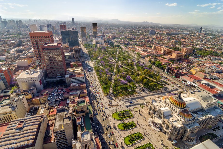
Capital Mexico City (9,155,000 pop., 18,942,000 urban aggl.)
Currency Mexican peso
Human development index 0.789 (81st place)
Languages Spanish (official), indigenous languages
Life expectancy M 73 years, F 79 years
Currency Mexican peso
Human development index 0.789 (81st place)
Languages Spanish (official), indigenous languages
Life expectancy M 73 years, F 79 years

Boundaries:
United States NORTH
Guatemala and Belize SOUTH-EAST
Pacific Ocean WEST and SOUTH
Atlantic Ocean EAST
GEOGRAPHY DATA OF MEXICO
Largest cities
Mexico City 9,155,000 pop., 18,942,000 urban aggl.
Tijuana 1,965,000 pop.
León 1,698,000 pop.
Ecatepec de Morelos 1,635,000 pop.
Puebla 1,615,000 pop., 2,162,000 urban aggl.
Ciudad Juárez 1,582,000 pop.
Guadalajara 1,375,000 pop., 4,528,000 urban aggl.
Zapopan 1,332,000 pop.
Monterrey 1,142,000 pop., 4,580,000 urban aggl.
Ciudad Nezahualcóyotl 1,068,000 pop.
Mérida 1,045,000 pop.
Chihuahua 998,000 pop.
Aguascalientes 943,000 pop.
Querétaro 905,000 pop., 1,067,000 urban aggl.
San Luis Potosí 885,000 pop., 1,019,000 urban aggl.
Torreón 718,000 pop., 1,384,000 urban aggl.
Toluca de Lerdo 522,000 pop., 1,749,000 urban aggl.
Highest mountains
Pico de Orizaba 5,636 m (18,491 ft)
Popocatépetl 5,426 m (17,802 ft)
Iztaccihuatl 5,230 m (17,159 ft)
Longest rivers
Rio Grande / Rio Bravo del Norte 3,060 km (1,901 mi) total, 2,001 km (1,243 mi) in Mexico
Colorado 2,333 km (1,450 mi) total, only a small final portion is in Mexico
Usumacinta 1,000 km (621 mi) total, including part in Guatemala
Balsas 771 km (479 mi)
Lerma 750 km (466 mi)
Largest lakes
Chapala 1,116 km² (431 sq mi)
Cuitzeo 306 km² (118 sq mi)
Largest islands
Tiburón Island 1,499 km² (579 sq mi)
Isla Ángel de la Guarda 930 km² (359 sq mi)
Cozumel 468 km² (181 sq mi)
ADMINISTRATIVE DIVISIONS OF MEXICO
Mexico is a federation of 31 states, with the capital forming a separate district; Chihuahua, Sonora and Coahuila, all located in the northern part of the country, are the 3 largest states, while the state of Mexico is the most populated and unique with over 10 million inhabitants, limit to which the federal district of the capital approaches.In 10 cities there are over one million inhabitants, while many others stay just below this limit; the distribution of the major urban centers is fairly well balanced between the various areas of Mexico.