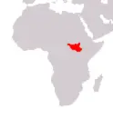
Republic of South Sudan
Government type Presidential republic
Area 644,329 kmē (248,777 sq mi)
Population 12,436,000 inh. (2026 est.)
Population density 19 inh/kmē (50 inh/miē)
Area 644,329 kmē (248,777 sq mi)
Population 12,436,000 inh. (2026 est.)
Population density 19 inh/kmē (50 inh/miē)
Capital Juba (582,000 pop.)
Currency South Sudanese pound
Human development index 0.388 (193rd place)
Languages English (official), Arabic, regional languages
Life expectancy M 56 years, F 59 years
Currency South Sudanese pound
Human development index 0.388 (193rd place)
Languages English (official), Arabic, regional languages
Life expectancy M 56 years, F 59 years

Boundaries:
Sudan NORTH
Central African Republic WEST
Democratic Republic of the Congo and Uganda SOUTH
Kenya SOUTH-EAST
Ethiopia EAST
GEOGRAPHY DATA OF SOUTH SUDAN
Largest cities
Juba 582,000 pop.
Malakal 161,000 pop.
Wau 151,000 pop.
Highest mountains
Mount Kinyeti 3,187 m (10,456 ft)
Longest rivers
Nile 6,850 km (4,256 mi) total
Bahr al-Arab 800 km (497 mi) total, with the stretch in Sudan
Bahr el Ghazal 716 km (445 mi)
Sobat (with Pibor) 675 km (419 mi)
Largest lakes
No 100 kmē (39 sq mi)
ADMINISTRATIVE DIVISIONS OF SOUTH SUDAN
South Sudan is divided into 10 states, to which must be added the two administrative areas of Pibor and Ruweng, in addition to the special administrative area of Abyei, disputed with Sudan; the state of Western Bahr al-Ghazal is the one with the largest extension, while Jonglei is the most populated one.At the 2008 census, only 12 inhabited centers had at least 15,000 inhabitants, with four of these over the hundred thousand mark; the distribution of the major cities and towns is quite homogeneous.
